Robin Hood’s Grave 10
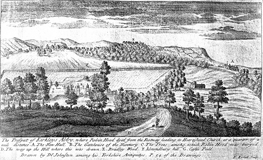
This is a reproduction of a plate that appears in the second volume of William Stukeley’s Itinerarium Curiosum 1776 (Plate 99). The plate is taken from a drawing that is possibly a stylised copy of Dr. Johnston’s original by Stukeley. The proportions and perspective are not entirely accurate; according to S.J.Chadwick the gatehouse at area B is a mistake, and the so called Gateway is more likely to have been the hall, parlour and prioress’s chamber. Alternativly, David Hepworth has suggested that the turreted buildings in the location of the old priory (area B of the drawing) were not standing even in Johnston’s day, and so must be a conjectural reconstruction.
.
The grave location has remained constant in the various maps of the estate from the eighteenth century onwards, which seem to mirror the seventeenth century prospect drawing by Johnston. Both Grafton and the Sloan Manuscript record that the grave was by the highway-side, but exactly where was this mysterious highway? A good account is given in The Site of Robin Hood’s Grave ( W.B. Crump, YAJ vol. 37 ) the following is from notes sent to him by the late George Hepworth, a well-known architect and surveyor of Brighouse.
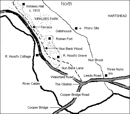
‘An ancient highway formerly led from the Obelisk called ‘Dumb Steeple’ (probably a corruption of ‘Doomed Steeple’, the bounds of sanctuary of Kirklees Nunnery) and skirted along the brow of the hill past the site of the Roman encampment and Robin Hood’s grave, and continued along through that part of the wood called the ‘Terrrace’ until it reached he old Entrance Lodge, near the village of Clifton. Passing the front of the Lodge, the road then turned to the right, and went across what is known by the name ‘Wood Fullans,’ and joined the lane called ‘Bleak Law Lane’ about a furlong above the group of cottages known as Bleak Law’…
‘This ancient highway was shut up and discontinued as a public road, being rendered useless after the making of the Elland and Obelisk Turnpike Road, which was constructed in the year 1815. The land occupied by the old road became the sole property of, and rested in Sir George Armytage Bart., the owner of the adjoining grounds. The track of this ancient road may still be traced on the spot, and is shown on the Ordnance Map of the district (6 inch Ord. maps Nos. 246 and 231 published in 1854).’
‘Reference is no doubt made to this road in the Sloane Manuscript on the death of Robin Hood, where the prioress after letting him bleed to death, buryed him under a great stone by the by-wayes syde.’
Some additional information is given by Crump. ‘The highway in question, called on the six-inch map, ‘Nun Bank Lane’ entered the estate of Kirklees at the Obelisk or Dumb Steeple, which still stands at what is now a busy road junction midway between Cooper Bridge (over the Calder) and the ‘three Nuns.’ It was always unfenced and therefore in mediaeval times it would be little more than a riding track or cart road whose course might vary as it ascended the slope………….. To return to Robin Hood’s grave. Its distance from Nun Bank Lane, as measured on the six inch map is 66 yards as compared with 166 yards down to the turnpike road. A grave at a distance of only three chains from the highway may be reasonably regarded as near it. Especially is this so in comparison with the Gatehouse which is nearly half a mile from the highway. It is quite natural for the ballads to describe the site of Robin Hood’s grave as ‘nigh the hye waye’s syde’. In the large map of the County of York by Thomas Jefferys (the first to show either the grave or the highway) ‘Robin Hood’s Grave’ is drawn so prominently on plate xii (dated 1771) that it touches the highway’.

|

